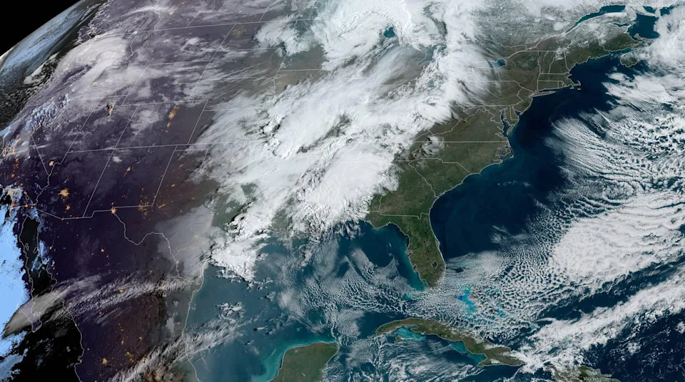
For the fourth week in a row, the continental United States will experience a multi-day severe weather outbreak. However, compared to the last three weeks, this severe episode will be different for a couple reasons.
First, it will affect areas farther north, stretching into the Central Plains, Upper Midwest and Great Lakes, which have not hit by the other outbreaks.
For this reason, the event this week will affect a much larger population than the previous outbreaks, including cities like St. Louis and Chicago, which have not yet experienced the severe storms.
The second reason is the event this week will also be more complex than the others, with several factors that could complicate the forecast in terms of storm placement, leading to lower confidence forecast overall compared to the other events.
On Monday, 13 million people were forecast to be under the risk for severe storms across the Southern Plains to Tennessee River Valley.
Tornado watches were issued for central and western Arkansas on Monday evening, and there was tennis ball-sized hail reported in Charleston, Arkansas, which is near the Oklahoma border.
Central and northern Arkansas had been eyed as potentially experiencing severe storms Monday due to the relative weakness of a “cap” — which is a warm layer of air aloft that that can suppress storm formation.
There was possible tornado damage in Logan County near Scranton on Monday, the sheriff said, but whether it was a tornado would have to be confirmed by the National Weather Service. There was damage to homes and buildings and downed trees, but no injuries were reported, the sheriff’s office said.
There were also reported tornadoes in Faulkner and Pulaski counties, according to the weather service. One tornado was reported northwest of Little Rock Air Force Base, it said. There was no major damage to the base, the base tweeted after an assessment.
On Tuesday, 39 million are under the risk for severe storms along a 1,000 mile stretch from southern Minnesota to the Gulf Coast. Very large hail and a few strong tornadoes are the greatest risks. Cities to watch include Des Moines, Iowa, Kansas City, Missouri, Wichita, Kansas, Tulsa and Oklahoma City, Oklahoma, Little Rock, Arkansas, Dallas, Shreveport and Baton Rouge, Louisiana, Austin, Texas, and Houston.
Storms are expected to continue into the overnight hours Tuesday into Wednesday.
A complicating factor for Tuesday’s storms will once again be the strong cap in place. This means that it is unlikely storms will stretch in a continuous line over the entire 1,000 mile risk area, but instead could be in broken clusters across the risk area. As of now, the area at greatest concern for the most widespread severe storms and strong tornadoes is across southern Minnesota, Iowa and northern Missouri.
Fast storm motions and the severe weather persisting after dark will compound the danger level of this set up.
By Wednesday, 62 million are under the risk for severe storms from the Great Lakes to the Gulf Coast including the cities of Chicago, St. Louis, Indianapolis, Nashville, Memphis, Little Rock, Shreveport, Birmingham, Jackson and New Orleans.
Strong tornadoes, very large hail and damaging winds will once again be possible.
Wednesday is the day when storms are most likely to affect the areas that were hit by the last three outbreaks. Storms will also continue overnight into Thursday morning.
The complicating factor for Wednesday’s severe storms will be widespread morning convection that could muddy the forecast and impact coverage and evolution of storms later in the day.
And as severe thunderstorms rage across the regions mentioned above, a crippling and potentially historic blizzard will be blanketing parts of the northern Plains and Upper Midwest.
This northern side of the storm system will feature a powerful snowstorm, capable of producing up to 2 feet of snow (isolated spots could see up to 30 inches of snow) and wind gusts to 50 mph. This will lead to impossible to life-threatening travel and could be damaging to crops and livestock.
Winter alerts were already up on Monday morning, stretching from the Pacific Northwest coast to the arrowhead of Minnesota. These included blizzard warnings for portions of Montana and the Dakotas.
On Monday it was already setting records across the Pacific Northwest with rare April snow falling in Portland:
The snow is forecast to spread into the Rockies and northern Plains by Tuesday and last through Wednesday.
A large swath of 6 to 12 inches of snow will be possible, with locally higher amounts of 18 to 24 inches possible across Montana and the Dakotas. These snow totals could be record-setting and historic for some areas:
In Bismarck, North Dakota, the largest April snowstorm is 17.8 inches set back in 2013. They are currently forecast to pick up 15 to 20 inches.
For Glendive, Montana, their total snow for this storm is expected to be around 13 inches. This would tie their previous 3-day record set back in 1896.
And if that wasn’t enough, the areas not affected by heavy snow or severe thunderstorms will be contending with high fire danger and strong winds.
On Monday, 12 million people were under Red Flag Warnings across the central and southern Plains. While fire danger Monday will be elevated to critical, a wildfire outbreak will be possible Tuesday when winds will be strongest. Wind gusts 50-60 mph combined with low humidity and temperatures in the 90s will lead to rapid fire ignition and spread.